GIS to aid first responders in emergency situations
Since the events that unfolded in Franklin County on April 27, 2011, local emergency personnel have been working on different ways to improve how first responders handle disaster situations in order to make rescue efforts more efficient and the county’s citizens safer.
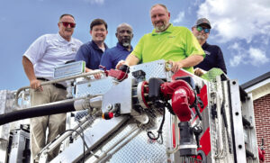
One of the newest tools developed by Franklin County GIS manager Michael Hughes and the Russellville Fire Department is a grid map for the city of Russellville that uses the same coordinate system that is used nationally.
Hughes took the GIS map for the city and plugged it into the national coordinate system to give each section of the city a certain grid number.
Hughes said this would make rescue or cleanup efforts more efficient in the event that something similar to April 27 ever happens again.
“Of course we hope we never have to utilize something like this, but the important thing is to be prepared,” Hughes said.
“No one would have ever thought an F-5 tornado would come through Franklin County, but it did. We just want to know that we have tried to cover all of our bases in case we have another weather-related disaster or other emergency.”
Hughes worked with Andy Devaney and other members of the RFD B-shift to create the grid map.
“This will be helpful in disaster-type situations because it will make coordinating agencies inside and outside of Franklin County easier,” Devaney said.
“When April 27th happened and we had agencies from all over the area coming in to help, we couldn’t tell them to go to a certain street ecause all the street signs had been blown away. We couldn’t give them a specific landmark to turn by to get to where we needed them to go because most of those were blown away too. It made it extremely difficult to direct the first responders.
“But having a grid map that coordinates with the national system that every agency in the country would be familiar with makes things much easier. If street signs are gone or people are unfamiliar with an area, we can just give them a grid number and they will know right where to go. Everyone will be on the same page.”
Hughes said that by linking the map to the GIS, emergency personnel can easily locate sections where a high concentration of people are located – the schools, the hospital, nursing homes and certain businesses – and make sure those areas are especially taken care of.
“There are endless possibilities and ways that this will be useful through the GIS,” Hughes said. “This could help with not only a severe weather outbreak but with things like wildfires, missing children or elderly adults, chemical spills, evacuations, ice storms – it really will make a big difference in any emergency.”
Russellville Fire Chief Joe Mansell said he appreciated the work by Hughes and others in the fire department for taking on this project.
“When we started talking about the tornado and how it had opened out eyes to certain needs, the guys just really got the ball rolling in an effort to make our citizens more safe, which is what we’re here for,” Mansell said.
“Like we’ve said, we hope we never have to use this system, but preventative measures can make all the difference sometimes.”