Public reports help forecasters keep track of severe weather
RUSSELLVILLE — Weather radar can show meteorologists a lot about a storm, but it cannot always tell them what is happening on the ground. That is where weather spotters come in.
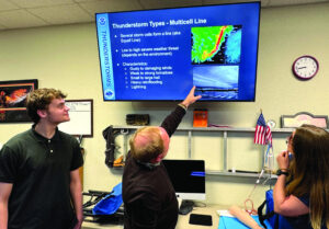
Meteorologists from the National Weather Service office in Huntsville recently led a free weather spotter training class in Russellville, explaining how reports from people in the community help forecasters confirm severe weather and issue warnings.
“I think a big part of our job is engagement with the community helping keep everybody safe,” said Meteorologist Katie Magee with the National Weather Service in Huntsville. Meteorologist Kris White joined Magee for the session.
Magee explained the National Weather Service provides the advisories, watches and warnings that trigger phone alerts and guide broadcast coverage during severe weather.
Technology such as radar and satellites gives meteorologists powerful tools to monitor storms, but those systems cannot always show exactly what is happening at ground level.
“We can’t be everywhere,” Magee said. “Radar can overshoot storms, so we depend on ground truth.”
Franklin County sits between the closest weather radars, she said, which can make reports from people on the ground especially useful during storms.
Magee also reviewed the difference between watches and warnings.
“A watch means the ingredients are there,” she said. “A warning means it is happening or about to happen, and it is time to act.”
She used a simple example to explain the idea.
“A taco watch means we have ingredients for tacos,” Magee said. “A taco warning means tacos are happening right now.”
Meteorologists encourage people to rely on more than one source for weather alerts.
“Social science shows people usually need two ways to realize something is happening before they take action,” Magee said.
The training also covered how severe storms develop and the types of storms that can produce damaging weather.
Thunderstorms form when moisture, rising air and lift combine in the atmosphere, Magee said. Severe storms also require wind shear, which means wind speed or direction changes with height.
Single-cell storms often produce brief heavy rain, lightning, and gusty winds. Clusters or lines of storms can produce stronger winds, flooding, and hail.
Supercell storms pose the greatest threat for large hail and strong tornadoes.
Magee also described visual features that sometimes appear with severe storms.
Shelf clouds form along the leading edge of storm outflow and usually point away from the rain.
Wall clouds form with a storm’s updraft and usually point toward the rain, she said, and those clouds can sometimes produce tornadoes.
The training also reviewed microbursts, which create powerful straight-line winds.
Microbursts form when cooled air sinks rapidly inside a storm and spreads outward after reaching the ground.
“That is sinking air,” Magee said. “It hits the ground and spreads out very quickly.”
Those winds can cause damage similar to tornadoes and may resemble tornadoes from a distance. Magee said the National Weather Service issues severe thunderstorm warnings when microbursts pose a threat.
The class also covered hail formation.
“Severe hail is one inch or larger,” Magee said. She cited a 5.34-inch hailstone that fell near Walter outside Cullman in 2018.
“That one was a cluster,” Magee said. “It looked like a fist with little claws.”
Strong updrafts allow hailstones to grow larger before falling to the ground, she said.
Participants also asked about the green tint that sometimes appears in storm clouds.
Magee said hail likely changes how light passes through storm clouds and can produce the green appearance.
The training also addressed tornado formation and safety.
“A tornado is a violently rotating column of air extending from the cloud to the ground,” Magee explained.
She said funnel clouds do not always reach the ground but can still develop into tornadoes.
Meteorologists rely on both radar signals and reliable reports from people on the ground when issuing tornado warnings.
“This is what we hate having to issue at two or three in the morning,” Magee said. “But sometimes it is probably for the best. You need to go seek shelter.”
She also warned against sheltering under highway overpasses.
“That is probably the worst thing you can do,” Magee said.
For shelter, she advised moving to an interior room on the lowest level possible and staying away from windows and doors.
“Cover your head and neck,” Magee said.
Meteorologist Kris White said reports from people who witness storms can play a critical role in confirming severe weather.
Radar provides valuable data, he said, but it cannot always show exactly what is happening on the ground.
“Flash flooding is a difficult thing for us to know exactly what’s happening,” White said. “It’s not something like a tornado. It’s not something like winds we can see on the radar, hail and that kind of thing.”
Because of that, the National Weather Service often depends on reports from the public.
White said the most useful reports include three key details — the time an event occurred, the type of weather observed, and the location.
For wind events, visible damage often provides the clearest clue.
“What we really care about is when the damage starts to occur,” White said, noting that broken tree limbs several inches in diameter or downed power lines can indicate severe winds.
Flooding reports can also help forecasters determine how serious a situation has become.
The National Weather Service advises never driving around barriers blocking a flooded road.
A road may have collapsed under the water. As little as six inches of fast-moving flood water can knock over an adult.
It takes just 12 inches of rushing water to carry away most cars and just two feet of rushing water to carry away SUVs and trucks. It is never safe to drive or walk into floodwaters.
White advised spotters to describe whether water is moving and to estimate depth using nearby landmarks such as signs or poles.
Because forecasters do not know every road or intersection, he suggested using nearby towns, intersections or recognizable landmarks when reporting severe weather.
White also cautioned people not to assume forecasters already know what is happening.
Reports from spotters can help confirm what radar suggests and sometimes helps forecasters respond more quickly to developing conditions.
White said accurate reports from people who witness storms help meteorologists confirm hazards they cannot always see directly.
“We’re not magical,” he said. “That’s why we need y’all.”